A flood watch and heat advisory are currently in effect for New Castle County on Tuesday. However, the area is expected to experience its heaviest rains later in the week as the remnants of Tropical Storm Debby make their way towards Wilmington.
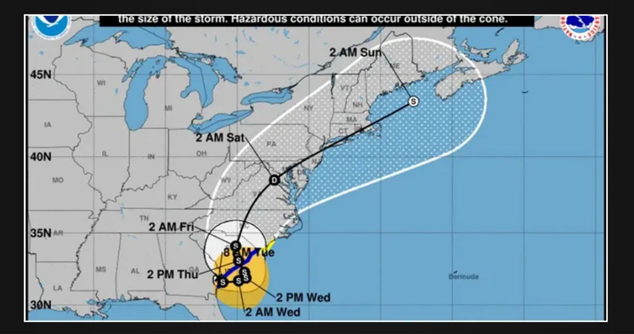
At 11 a.m. on Tuesday, the tropical storm was located on the border of Georgia and South Carolina. The forecast predicts that it will move into the Atlantic Ocean before making landfall and traveling through South Carolina.
Is Tropical Storm Debby hitting Delaware?
The National Hurricane Center has forecasted that Wilmington will experience the brunt of the storm on Saturday. The storm is expected to hit New Castle County as a tropical depression.
According to the latest forecast, New Castle County will experience heavy rainfall of 4-6 inches from the approaching storm that is expected to pass through on Saturday and last until Sunday. Kent and Sussex counties are also likely to receive 2-4 inches of rain during this time. While it’s still too early to determine if the storm will result in severe weather, it’s imperative to note that flooding could become a significant concern following the rains that occurred on Tuesday, Wednesday, and Thursday.
Lee Robertson, the observing program leader at the National Weather Service’s Mount Holly, New Jersey, office, expressed his primary concern about the heavy rainfall. He emphasized that the saturation of the ground due to heavy rainfall increases the potential for flooding.
When heavy rainfall saturates the ground, it can cause problems with trees. As per growingearth.com, when the soil becomes oversaturated, the roots can lose their grip and uproot, particularly when there are strong winds.
What is a tropical depression?
According to the National Weather Service, the storm is expected to move through New Castle County as a tropical depression. In simpler terms, this means that it is a type of tropical cyclone with maximum sustained surface winds of 38 mph or lower.
Delaware weather forecast
According to the National Weather Service’s forecast for Tuesday, the heat indexes are expected to range from 99 degrees in Dover to 93 degrees in Bethany Beach. A heat advisory has been issued for New Castle County until 10 p.m. on Tuesday, and this high temperature can adversely affect vulnerable populations. Therefore, it is essential for older adults, children, and those who are unwell to take precautions to keep themselves cool and hydrated throughout the day.
On Tuesday afternoon and evening, a refreshing cool front is expected to arrive in the area. As it interacts with the tropical moisture from Tropical Storm Debbie, heavy tropical downpours are likely to occur in the late afternoon and evening. It’s worth noting that New Castle County is under a flood watch starting from Tuesday evening until Wednesday morning.
How to stay safe in a flood
When heavy rains are in the forecast, it’s crucial for individuals to stay vigilant and cautious. According to ready.gov, a website operated by the U.S. Department of Homeland Security, here are some recommendations to keep in mind:
-
- Evacuate immediately, if told to evacuate. Never drive around barricades. Local responders use them to safely direct traffic out of flooded areas.
- Listen to EAS, NOAA Weather Radio or local alerting systems for current emergency information and instructions regarding flooding.
- Do not walk, swim or drive through flood waters. Turn around. Don’t drown!
- Stay off bridges over fast-moving water. Fast-moving water can wash bridges away without warning.
This Article Includes