Good morning everyone! As anticipated and predicted, the tropical energy that was leaving has transformed into a coastal storm, but fortunately, it is moving further away into the sea. It is currently interacting with a front that is sweeping through the Northeast region. Consequently, we can expect some gusty winds, cloudy skies, and a bit of drizzle along the coastal areas. The good news is that this system is moving at a decent pace, which means that the clearing process will be swift and we can look forward to clearer skies today.
As we move into the weekend, cooler weather will gradually settle in. Temperatures will dip into the 60s, followed by a larger drop into the 50s for Sunday and Monday. In addition, there is a possibility of heavy frost overnight on Sunday, particularly in the interior sections of the Northeast. This frost may be more pronounced in higher elevations and valleys.
We are closely monitoring the current onshore flow occurring along the eastern shores of Florida. Although there are still a few tropical showers and rumbles brushing the coast, the risk of rough seas and beach erosion has diminished. However, we are still experiencing some higher tides that may result in minor coastal flooding.
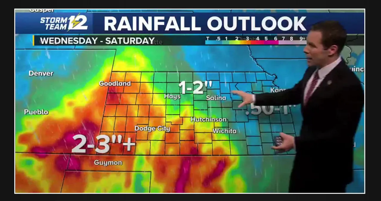
The Midwest is currently experiencing a severe weather risk, particularly in parts of Nebraska, Iowa, Kansas, and Missouri. A cold front, which will bring cooler temperatures to the Northeast on Sunday, is slowly moving across the Midwest. As this front interacts with warmer and more humid air, it will generate enough convection later today and this evening to produce clusters and lines of heavy showers and thunderstorms.
Clusters and lines are expected to form storms that have the potential to reach severe limits. These storms may bring locally damaging winds, large hail, frequent lightning, torrential rain, and there is also a risk of an isolated tornado. Additionally, there is a possibility of this weather activity spreading into Illinois and Wisconsin overnight.
Here is the forecast for the NYC Metro area.
Clouds and drizzle will clear, making way for sunshine throughout the day. The breeze will pick up slightly, with northerly winds reaching gusts of up to 25mph. However, tomorrow will bring calmer weather, with temperatures in the mid 60’s and a pleasant atmosphere.
On Saturday, we will be enjoying temperatures in the mid-60s. However, there won’t be any significant weather activity as a front passes through due to the dry conditions. On Sunday, we can expect highs in the range of 55-60 degrees, accompanied by a steady breeze.